


Ground magnetic survey has proved a boon to archaeologists studying the Middle Bronze Age period in Anatolia
When archaeologists undertaking surface surveys at a site near Afyon in western Turkey about five years ago unexpectedly came across a grave on the surface, they knew they were on to something. It was near an area already known for an ancient necropolis and had several similarities to it, but with limited funding to excavate the entire research area they couldn’t be sure what lay beneath.
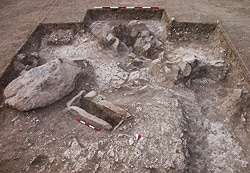
Aydin Buyuksarac was at the time an associate professor in the Department of Geophysical Engineering at Cumhuriyet University in the Turkish city of Sivas and a member of the team. “They started to excavate but could not decide where the start point was and where they could stop,” he recalls. Buyuksarac had a suggestion. “Geophysical investigations could give an idea, and limitations about the area,” he says. It worked. Sure enough, the site was revealed and confirmed as a necropolis; and now called the Dedemezari Necropolis.
Buyuksarac is, as are most archaeologists, sold on the use of geophysical methods, such as the magnetic survey they used at Dedemezari, to find elusive underground cultural remains that could otherwise entail extensive costs and still only provide hit-or-miss solutions. “Some classic archaeological exploration methods such as trenching and drilling require an enormous expenditure of human energy and engender high costs,” he says. “Moreover, these classic methods are destructive for archaeological sites. Developments in image processing and graphic representation of geophysical data provide high-speed, non-destructive reconnaissance surveys.”
Magnetic surveys in particular have proven useful. Underground cultural and archaeological features usually harbor remnant magnetization that can in a local sense bend the Earth’s magnetic field. These disturbances can be accurately and precisely measured with today’s highly sensitive magnetometers. The method’s effectiveness is a function of the level of contrast between the buried features and their local environment.
Some of the most common artifacts that produce measurable magnetic anomalies are items of fired clays. The reason for this is simple: objects such as kilns, bricks, tiles, pottery and grave jars have remnant magnetization which was induced in the firing process—these show up as contrasts with local magnetic fields. Measuring these, processing and correcting the magnetic data, then using sophisticated digital image processing techniques to sharpen and enhance the magnetic anomalies formed around the buried items can paint a grand picture of what lurks beneath.
Which is particularly useful and applicable when used to assist archaeologists’ searches for buried graves. Most very ancient graves, cemeteries and necropolises are devoid of telltale surface indications; and often contain buried artifacts harboring remnant magnetizations.
Buyuksarac and his colleagues from Selcuk University along with two researchers from Ankara University first proved out this magnetic technique investigating another necropolis, the Harmanoren Necropolis. The Harmanoren dates to around 2500 BC and is the third largest necropolis in southwestern Anatolia. They surveyed at a sampling frequency of two metres in three adjacent areas. They then applied linear transformations, horizontal planar removal, and reduction of the pole and analytic signal to transform the signals to readable subsurface images. This outlined several attractive locations of potential burials. Based on these determined locations, excavations then easily revealed several ceramic grave jar burials exactly as predicted. To ensure it wasn’t just luck, magnetic susceptibility measurements of samples from the excavated jars showed that the observed magnetic anomalies could have been caused by them.
Other archaeological researchers have had good success with the magnetic method too. Buyuksarac and his colleagues write of Gaffney and his team who in 2008 reported using a magnetometer with a three-probe cart system at the Cyrenaica Archaeological Project in northern Libya. Another reported, also in 2008, using a rapid and sensitive magnetometer with SQUID (Superconducting Quantum Interference Device—a sensitive magnetic flux detector) to survey a Neolithic double-ring ditch at Niederzimmernnear Weimar, Germany. All showed how large areas can be mapped accurately and in short order.
And so it was at the Dedemezari Necropolis, which archaeologists believe was initially built around 2000 BC and belongs to what they term the Middle Bronze Age. “The Dedemezari Necropolis was used between 1900 and 1550 BC,” says Buyuksarac. “So we can say it is from the pre-Hittite period.” This period in southwestern Anatolia is when the Luwians established themselves. The Luwians were an Indo-European-speaking peoples thought by historians to be responsible for some rather violent destruction of existing settlements when they invaded the region and may have been the earliest wave of the better-known Hittites to the area. One of their dialects was in fact incorporated into many Hittite hieroglyphs.
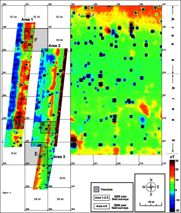
Buyuksarac headed up the magnetic survey of the Dedemezari Necropolis, which was supported by TÜBİTAK (The Scientific and Technological Research Council of Turkey). Over 3,600 square metres were surveyed using a sensitive proton magnetometer (Scintrex Envimag System with 0.1 nT sensitivity at 2-second sampling rate). This provided the total intensity of the magnetic field. His team used a method referred to as the tie-point correction for magnetic diurnal variations instead of the conventional base station method. He explains that tie-point corrections involve the use of one magnetometer and the repeated measurement of magnetic values at a single survey station throughout the day’s survey operations. Data were collected sequentially in the continuous mode at 0.2m sample intervals along profiles with 0.5m profile intervals; the sensor height was 0.5m above the surface. Recorded data sets were gridded using the kriging method (an interpolation technique). To avoid skewed magnetic anomalies, data were corrected for the non-verticality of the magnetization and ambient field by the reduction to pole (RTP) method.
The resulting map of analytic signal-transformed anomalies was then put to the practical test: excavation. Trench locations were chosen based on the magnetic survey and excavations undertaken. Archaeologists were thrilled: three types of grave were found. One made of clay, one carved into the rock and the other a simple grave. Not only were locations accurate but grave shapes were predictable. Shapes of the anomalies associated with the buried graves were mainly cylindrical and elliptical; the elliptical anomalies had negative magnetic values with no positive poles. The circular anomalies with positive and negative poles indicated either carved rock or simple graves. Generally, low magnetic anomalies indicated grave jars and the higher ones were produced by supporting stone that formed the sides of a grave. Because empty grave jars have very low magnetism, the susceptibility contrasts were also low. “The magnetic method was very sensitive to these kinds of archaeological materials due to heated kiln features,” says Buyuksarac.
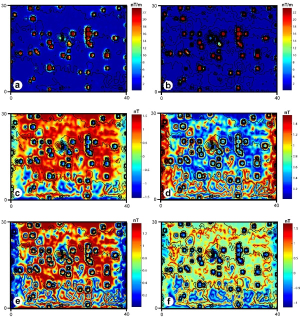
Buyuksarac attributes much of the interpretation success to the use of magnetic field derivatives, both vertical and horizontal. He reckons interpretation of magnetic field derivatives, separately or together, provide good images of shallow bodies from magnetic data while at the same time reducing the field from deeper sources. Horizontal derivatives of the total magnetic field were computed in the space domain using finite-difference relationships; vertical derivatives were computed in the frequency domain using fast Fourier transform (FFT) filtering.
The other major contributor to the project’s success was the use of Geosoft software for the data processing, mapping and analysis. “The gridding capabilities within Oasis montaj were very useful and highly sensitive,” says Buyuksarac. “That’s why we firstly gridded the magnetic data. And then RTP transformations were applied to the gridded data. For analytic signal transformation, all magnetic maps were processed by computation of their horizontal-x, horizontal-y and vertical-z derivatives using Geosoft’s Oasis montaj gravity and magnetics interpretation extension software. It provided a good solution for our project needs, and produced the results we required.”
Overall Buyuksarac extols the advantages of using the magnetic method to search for graves. “The magnetic method was very successful,” he says. “Locating the graves was very fitting and excavations verified the suggested locations on the site.” Some proved highly interesting, especially one in particular which appeared to be in a close grouping. “We interpreted these as a family grave group,” he says.
One of the settlements thought to have been invaded by the Luwians was Hissarlik, a fortified Bronze Age settlement site on the south shore of the Dardanelles which has been identified with the Homeric city of Troy. Coincidentally, nearby Canakkale has now become Buyuksarac’s new home. “I changed my university at the beginning of 2010,” he says. “I am now head of the department of geophysical engineering at Canakkale Onsekiz Mart University.” He may well have several new potential magnetic survey opportunities right in his backyard. “There were a lot of civilizations [throughout] the history of this city,” he says.
Principal source:
“Determination of Grave Locations in Dedemezari Necropolis (Western Turkey) using Magnetic Field Derivatives”, by A. Buyuksarac, M. O. Arisoy, O. Bektas, O. Kocak and T. Cay. Published in Archaeological Prospection (15), 2008: online in Wiley InterScience (https://onlinelibrary.wiley.com)