


Three-dimensional geological modelling with Seequent’s Leapfrog Geo helps discover the extent of vital community water supplies.
Water resources around the world are under increasing pressure from the warming climate and a growing global population.
The need for communities to find sustainable sources of drinking water is becoming ever more urgent. The water you need may be just below your feet, but the challenge is working out the scale of the resource and how best to access it economically and in a way which doesn’t affect the environment.
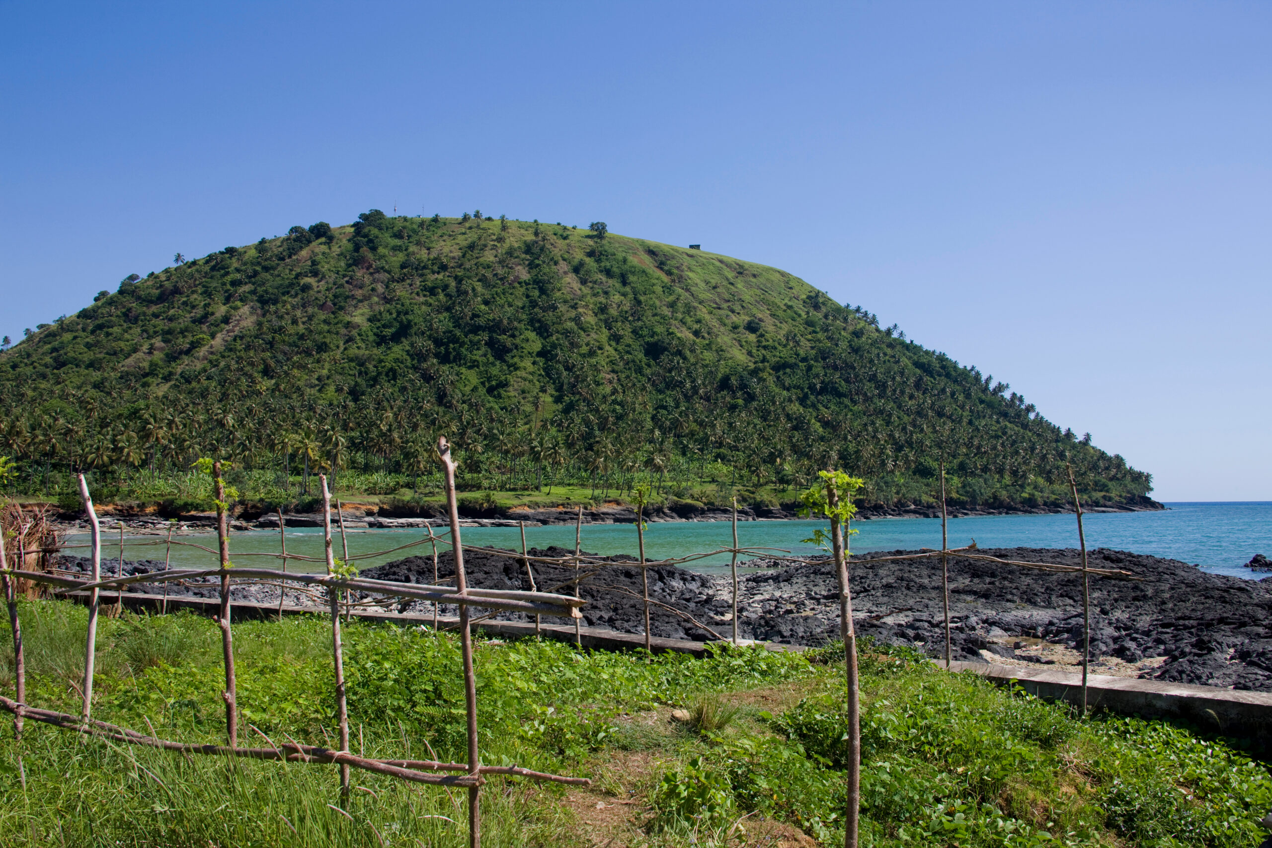
Grande Comore is the largest island of the Comoros archipelago in the Indian Ocean between mainland Africa and Madagascar.
Home to about 400,000 people, the volcanic island is largely deprived of rainfall-fed surface water, which quickly runs into the ground through cracks in the rock and feeds deep aquifers whose nature is still not well understood.
Building a more comprehensive knowledge of the island’s groundwater potential would help assure residents they can have a secure future with an adequate water supply, even with the effects of climate change.
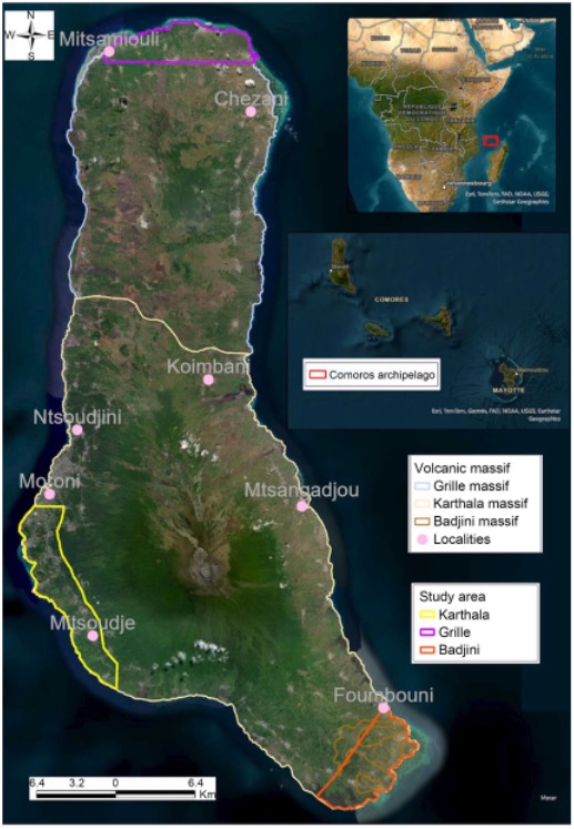
Figure 1: geographical location, volcanic massifs on the island and areas
3D modelling to solve water scarcity
Academics from Comoros, Senegal, and France recently investigated how three-dimensional modelling can improve the understanding of the flow of groundwater into fragile aquifers in a complex volcanic environment.
In a paper in the Open Journal of Modern Hydrology, researchers used Seequent’s Leapfrog Geo to more accurately show the extent of Grande Comore’s groundwater.
Grand Comore comprises three volcanic massifs of differing ages and activity. The island has little surface water due to rain rapidly streaming through fissures and down to the deep water table.
Wells have been drilled for water exploration in the past. About 40 wells close to the coast were put in during the 1980s as part of the United Nations Development Programme. Between 2012 and 2019, the French Development Agency sunk eight deep wells further inland. This was deemed a success and sparked the Water and Resilience to Climate Change (WRCC) project, financed by the Green Climate Fund. This plan is to drill six new boreholes by 2030 to strengthen the groundwater monitoring and exploitation network.
The authors said the WRCC work was not aimed at understanding hydrosystems, but rather at harnessing and exploiting them. However, it ‘revealed the potential of aquifers in certain areas of the island’s massifs, and the threat of marine intrusion, which merited further study’.
‘Today, software such as Leapfrog Geo offers the possibility of building a 3D geological model with a more accurate representation of the subsurface. Statistical tools such as ordinary kriging can be used to simulate the spatial distribution of groundwater.
‘These modelling approaches were combined to improve knowledge of the groundwater flow context. The delineation of the 3D geometry of litho-stratigraphic units has enabled a more detailed conceptualisation of groundwater flows in a complex volcanic environment,’ they said.
Combining modelling approaches
While there was an absence of data in the central parts of each massif, with uncertainties about the geometry of those aquifers, the models provided valid hypotheses for characterising the hydrogeological configuration of each.
‘Implicit geological modelling offers several advantages, including the ability to generate models quickly by creating geological contact surfaces from limited data, integrating many types of data, and reducing the need for manual intervention through automation.’
However, modelling could encounter difficulties in representing complex geological features when input data was limited, as in this study, leading to less accurate geological interpretations. Also, drilling data might not reflect geological heterogeneity at depth.
‘By combining drilling data with other geological information and implementing appropriate controls, it is possible to mitigate the difficulties encountered and improve the efficiency of the geological model.
‘Although it enables the stratification of geological formations to be visualised in 3D, the implicit geological model alone does not, in some cases, enable the hydrogeological system to be conceptualised, especially in a complex geological environment.
‘For this reason, we have proposed in this study a combination of implicit geological modelling with piezometric interpolation to properly represent aquifers.’
Piezometric interpolation is a method used to estimate the water level at a specific location when you only have measurements from a few surrounding wells or sensors.
Nature of aquifers revealed
The study found a mix of deep basal aquifers and perched hydrosystems at high altitudes in the three volcanic massifs.
‘It was also found that in all three massifs, groundwater flows from the central part towards the coast. It is accepted that groundwater is probably recharged from the central areas of the massifs, which are often characterised by high rainfall and the presence of specific geological structures such as faults, caves, calderas, and craters, which can encourage the direct infiltration of rainwater into underground hydrosystems.’
The modelling enabled better understanding of the aquifers and how they functioned, ‘with the aim of better ensuring their rational and sustainable management in the face of the major challenges of increased exploitation of resources, degradation of water quality, and climate change’.
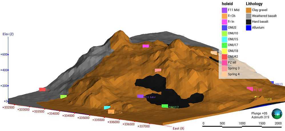
Figure 2: 3D geology of Badjini massif
‘This study could contribute to rational water management, helping local authorities to identify areas with high groundwater potential, areas to be exploited with caution, and the water-flow context.
‘By highlighting the different aquifer structures on Grande Comore Island, the study also opens up the possibility of addressing other groundwater-related themes, such as groundwater hydrodynamics, saline intrusion, water quality and recharge processes,’ the authors said.