Geophysics is now on Netflix. Finding water for refugees, increasing safety in mines, and even assisting in archaeology, Alastair McClymont’s projects have had such a global impact that they feature in documentaries.
Alastair is a principal consultant for Advisian and specialises in near surface geophysics. His clients span industries and require him to work alongside stakeholders with a variety of specialisations and technical levels.
“Part of the real challenge of delivering a successful project is communication. Understanding clearly how the geophysics is going to reduce the risk profile on any particular project,” Alastair explains.
Geophysical techniques measure the physical properties of an area that then can be related back to soil, geological, or water conditions.
“For example, we may be measuring the way that seismic waves travel through the ground or measuring how well soil or rock conducts electricity – that can tell us something about the geology in the ground.”
Alastair shared a few case studies showing how people in different industries are harnessing geophysics in his presentation at Vancouver Lyceum, Seequent’s annual user conference. You can watch his full talk here:
Keeping a levee strong – geophysics for engineering
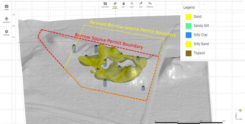
An engineering project needed more sand to create a pond embankment. After a geotechnical team dug a series of test pits, the results didn’t provide enough certainty to determine whether there was enough sand in their permit zone that could be recovered for constructing the embankment.
“The client said, ‘Okay, do I have 40,000 cubes of sand?’ And our engineers said, ‘We don’t know.’ So, they came back to our geophysics group and asked, ‘What can you do to improve on this?’”
His geophysics team undertook an electrical resistivity tomography (ERT) survey to measure how well the soil conducted electricity across the site.
“Sand is quite resistive, finer grain materials like clays are less resistive. So, it’s a good tool for differentiating between clay and sand. And we found we had pretty good correlation,” Alastair explained.
“We then took that those high resistivity values that we could correlate to the sand and said ‘Let’s look at this distribution. Let’s put it into Leapfrog Works and let’s do some just some basic 3D modeling.’”
The results showed that a sufficient volume of sand existed in the permitted area but, by modifying the permit boundaries, a greater volume of sand could be recovered.
Alastair went back to his client: “Why don’t you just change your permit and push it farther out this way? You’re likely to get that extra sand that you need to build the embankment.”
By clearly explaining the uncertainty and giving the client and his team a 3D picture of the geophysical data, Alastair helped his client make informed decisions about their project.
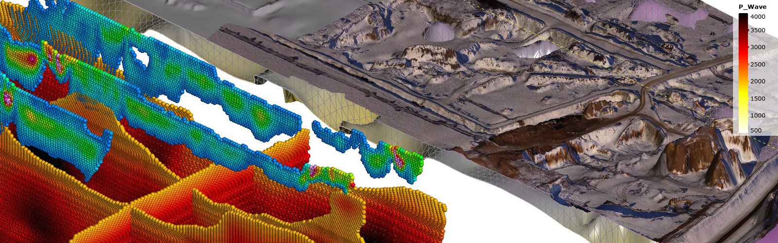
Dodging karst in a limestone mine – geophysics for mining
Jagged karst dissolution features are a challenge for geologists – especially in a limestone mine where they can naturally occur. Alastair had a mining client who wanted to recover high-grade limestone while avoiding the troublesome karst.
“[They] are a problem for two reasons. They lower the quality of the rock. And, they’re also a geohazard when they’re mining. These were potential collapse features that were impacting their mining operations.”
The mine had drilled 23 boreholes to identify karst features but found that they still had missed many of them. They enlisted Alastair and geophysics for help.
“We’re probably not going to be able to recover exactly the shapes of those karst features, but we can probably tell you where they are and their spatial distribution,” he explained.
His team used the seismic refraction technique, which measures the compression wave velocities of a material. Hard rock produces fast waves while loose materials, like soils or hollow spaces, produce slow ones.
“We got some seismic refraction profiles… We removed the slow velocities to show the top of the limestone surface. And then we removed the even faster velocities to show where you likely had these karst features as well.”
Gaps of soft material or empty space surrounded the hard limestone and gave the mine an idea of which places to avoid.
“This gave them the information they could take to go on and make decisions about where to expand the mine, and which areas would be problematic.”
Finding water for refugees – geophysics for humanitarian aid
Kutupalong refugee camp in Bangladesh is the largest refugee camp in the world. Nearly one million people make up the population of this camp and its satellites.
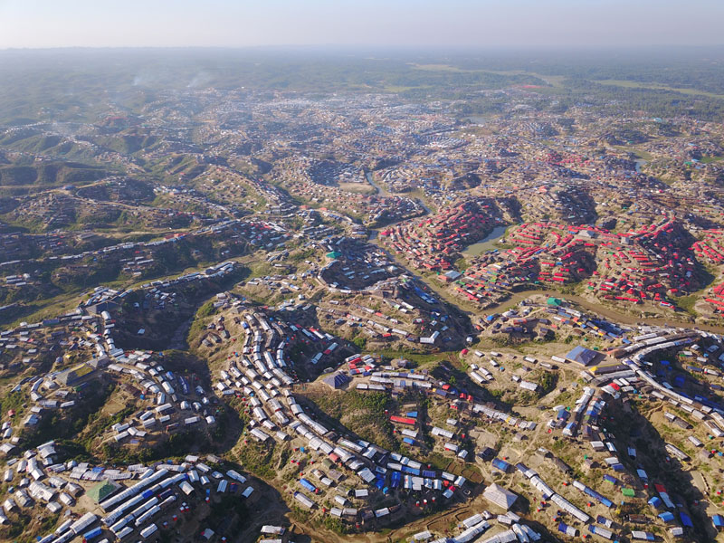
Water scarcity had become an issue as the camp grew. The United Nations High Commissioner for Refugees asked Alastair and his colleagues if they could assist with a groundwater exploration program.
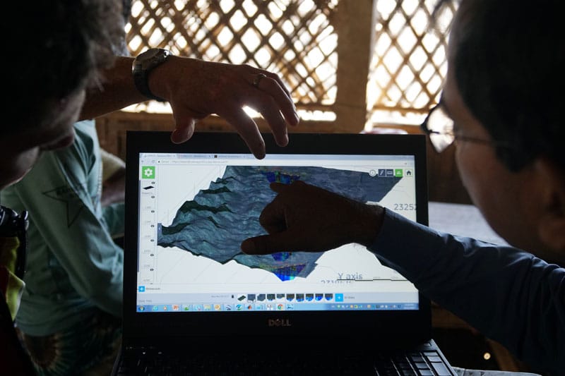
“We were doing ERT because it’s a very good tool for finding these more granular, more permeable type aquifers that would be suitable drilling targets for water wells,” Alastair said.
“We also brought a UAV (unmanned aerial device) with us which was an invaluable tool for helping plan out lines.”
The camp was filled with so many people and structures that clear survey lines could only be scouted from above. At first, the ERT showed only sandstone units, with little continuity between them.
“So just looking at them a cross section. These aren’t very big aquifers that will yield a lot of lot of water. We thought maybe if these ridges extend farther south, they may have higher potential,” Alastair said.
The ERT surveys farther south showed some deep sandstone ridges near the camps.
“Talking to the landowners, we got a sense of the layout of existing wells in the area, including the locations of the poorly producing wells and the higher producing wells, some with motorized pumps indicating they were tapping relatively good quality aquifers.”
“So, in our Leapfrog model, we just plotted up where we had these good wells and where we had the poor ones. We found an excellent correlation between the aquifers mapped by our geophysics data and the locations of the higher producing wells.”
His team’s biggest challenge wasn’t geological – but time. They only had two weeks in the field and had to run surveys and then communicate the results to Non-Governmental Organizations (NGOs) on the ground.
“It was really key for us to get a 3D model together while we were in the field. We actually went into the camps, we talked to the NGOs (who are drilling these wells), the various stakeholders, and we would just bring up our model and say, you know, these are good spots to drill here and here,” he said.
By communicating clearly, the team not only found some good quality drilling targets for wells for the camps but also showed areas to be avoided, where it would be wasteful to install new wells.
So, why use geophysics techniques?
The most obvious reason is that they are non-invasive.
“There’s minimal environmental disturbance. You’re not clearing trees. There’s reduced ground disturbance. So, you can drill fewer boreholes or excavate fewer test pits,” says Alastair.
Also, in areas with dense populations or challenging topography, it would be nearly impossible to collect information using on the ground field geology or geotechnical methods.
“We can also get data from areas that we might not otherwise be able to get data from. You get spatially continuous data so you can connect the dots between your point measurements.”
Which is why the techniques are so widely applied that they’ve even made their way into documentary film. The next time you scroll through Netflix, don’t be surprised to see geophysics in action.