Due to changes in global brine reporting guidelines hydrogeology experience has become more relevant in reporting brine resources, with this change hydrogeologists are having to learn new skills. The user-friendly and highly visual resource estimation solution, Leapfrog Edge, presents the perfect solution.
The Project
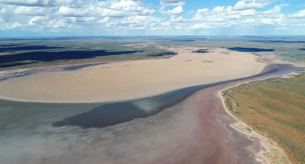
Advisian, the independent consulting arm of the WorleyParsons Group, provide end-to-end solutions, including Geosciences and Water Specialist Services globally. Advisian’s client, Kalium Lakes, is probably the most advanced of a small group of Australian exploration companies looking to produce high-grade premium Sulphate of Potash (SOP) fertilizer from potassium-rich brine.
Advisian used resource estimation solution, Leapfrog Edge, to estimate the potash brine resources in Western Australia to JORC (2012) and NI43-101 standards. Kalium now have a Bankable Feasibility Study and is currently progressing Front End Engineering Design studies prior to a final investment decision in the next few months.
This project, although applying similar modelling techniques to those used in lithium brine resource estimation in South America, is the first time the conversion from a brine Mineral Resource using a transient ground water flow model has been completed to estimate a brine Ore Reserve in Australia.
Advisian’s Principal Hydrogeologist, Australia, Adam Lloyd explains, “Typically, static brine resources in Australia and North and South America have been completed by experienced resource geologists. Due to a number of changes in global brine reporting guidelines (NI43-101 and draft AMEC) brine resources now suggest that hydrogeological experience is relevant and therefore hydrogeologists are learning these skills. Although I have a degree in Resource and Applied Geology and have been responsible for data collection and interpretation on a number of brine projects, I am principally a hydrogeologist and I had not completed an independent resource estimate prior to this work. The ease of use and Edge’s data presentation functions have allowed me to learn the skills needed to develop and communicate the resource estimate with relative ease.” The work has been supervised by Competent Persons from K-Utech, a German Consultancy specialising in Salt Mining and Processing.
Leapfrog Edge is a cost-effective resource estimation solution that seamlessly integrates with Leapfrog geological models and includes intuitive, highly visual tools within a streamlined and flexible workflow that is easy for users to learn. The software’s powerful interactive data visualisation, often in 3D, adds to ease of use and is a new innovative approach to resource estimation and is a distinct advantage over other solutions.
Application of Edge to Potash estimation
The end product of the resource estimate is Sulphate of Potash (SOP) fertilizer, which is measured in brine contained within aquifers as concentration of potassium and sulphate.
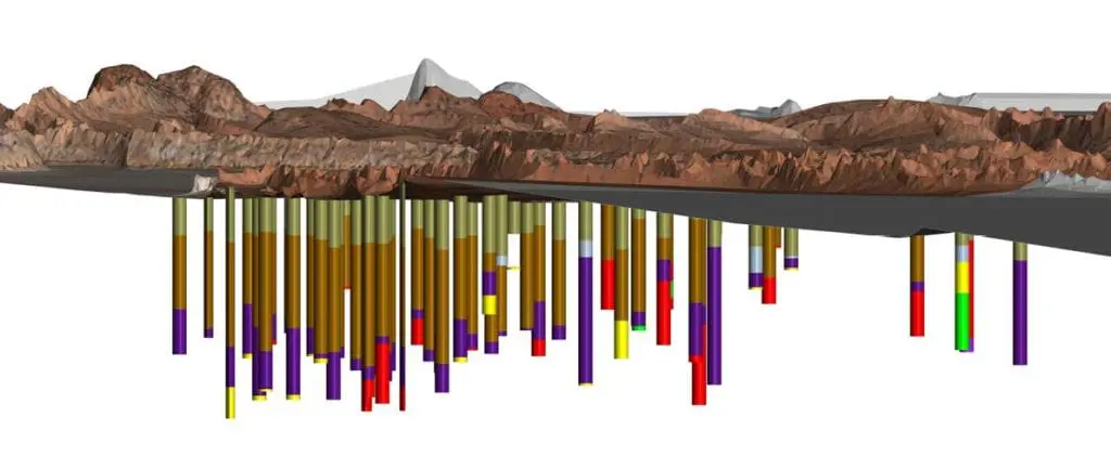
Brine is sampled across the resource by drilling and pumping of the aquifers and surrounding strata. As the resource is a brine the volume in each geological unit is different due to the hydraulic properties of the aquifer (or aquitard), namely drainable and total porosity properties. Both of these parameters are determined for each geological unit, using a combination of laboratory tests, aquifer tests and calibrated geophysics (borehole magnetic resonance).
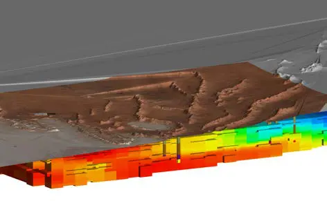
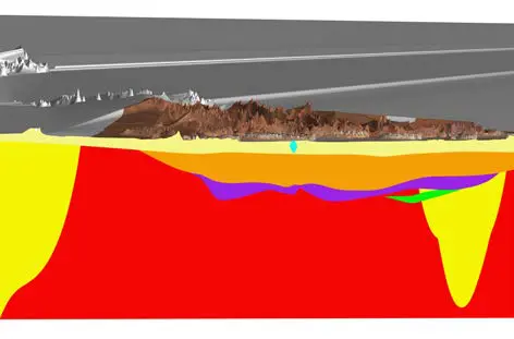
The assay results of the brine were used to develop the block model in Leapfrog Edge, providing a distribution of grade across the resource and each geological unit. The drainable volume of brine and the total volume of brine was then estimated and the statistics from Leapfrog Edge used to calculate the tonnes of potassium and sulphate within each geological unit.
The Leapfrog Edge block model was then imported into a FeFlow hydrogeological model (finite element groundwater flow and solute transport model) to simulate various Mine Plans and an Ore Reserve estimate from pumping of wells and trenches.
“The ease of use and Edge’s data presentation functions have allowed me to learn the skills needed to develop and communicate the resource estimate with relative ease.”
Adam Lloyd, Principal Hydrogeologist, Advisian Australia
Innovative 3D visualisation
Presented in streamlined, easy to follow workflows, Leapfrog Edge includes all of the standard tools for estimation, domaining, geostatistical evaluation and reporting while introducing the innovative use of 3D visualisation to resource estimation. These highly interactive tools bring clarity and help users gain a greater understanding of their data. Users can rapidly iterate and test different parameters and then view the results in the rich 3D environment, whether it’s variography, estimation results or reporting and summarising.
Useful tools and features include:
Cross-sectional exports – an easy way to demonstrate where data collection is more concentrated or sparse and therefore easy to see where the model has more control from increased drill hole and downhole sample spacing.
Swath plots – a great visual tool to review multiple estimates to see where the resource estimate sits in relation to sensitivity or comparisons between estimate methods.
Visualisation – Edge’s powerful visualisation brings peer and due diligence reviewers quickly up to speed with the nature of the extent, degree of sampling and ultimately confidence in the modelled outputs.
Adam comments, “Leapfrog Edge has been really useful in presenting QA/QC data and plots for reporting, it has really saved time and has enabled me to use technology to best effect. It’s also helped a hydrogeologist, who hadn’t completed a complex resource estimate before to get some credibility in resource estimating.”
A Leapfrog Geo user since 2012, Adam had already completed the project’s geological models in Leapfrog Geo and going into the project’s Bankable Feasibility Study was looking for a cost effective and streamlined way to significantly update the project’s resource.
“After reviewing Edge’s capabilities and graphical presentation it was the logical choice. Also, the cost-effective aspect of Edge cannot be overlooked. Without Leapfrog Edge I would have had to invest significantly in the cost and time of learning other software. I’d also have to complete extra exports and imports of model layers and data to go between Leapfrog Geo and another piece of software, as opposed to seamlessly using Leapfrog Edge within Geo.”
Dynamic Updating
This seamless connection relies on building the estimate from the original Leapfrog model and avoids data corruption and error. A key feature of this integration is ‘dynamic updating’, where users can add data or revise their interpretations at any stage in the workflow and these changes will automatically flow downstream and update.
Adam explains, “We will be constructing additional production bores and completing further exploration to refine the geology around some of the expansion areas, so it will be useful to constantly update the geological model. Similarly, Edge’s dynamic updating capability will be useful when we produce a new resource estimate.”
“Without Leapfrog Edge I would have had to invest significantly in the cost and time of learning other software. I’d also have to complete extra exports and imports of model layers and data to go between Leapfrog Geo and another piece of software, as opposed to seamlessly using Leapfrog Edge within Geo.”
Adam Lloyd, Principal Hydrogeologist, Advisian Australia
Supporting Theories
A key outcome of the modelling was that the block models showed brine grade reducing at a lower rate away from the lake in the down hydraulic gradient portion of the deposit where the main measured resources had been targeted at Ten Mile Lake.
Adam says, “The highest producing production bores are located on the down hydraulic gradient side of Ten Mile Lake, supporting the concept that brine is flowing within the palaeochannel aquifer at depth away from the lake. This helped target exploration and estimate the Resource up to 5km away from the lake in this area. Therefore, the block model is supporting our theory around the conceptual hydrogeology. This cross over has been quite nice to present and demonstrates why the borefield is where it is.”
Conclusions
Launched in 2017, Leapfrog Edge, is the culmination of three years of industry consultation including research, development, testing and validation with resource geologists and geostatisticians from around the globe. The result is an easy to follow ‘next generation’ solution that supports and advances industry practices. Thoughtfully crafted with intuitive, yet flexible workflows and uncluttered work spaces designed to improve productivity and reduce training time.
Comments, Mike Stewart, Seequent’s Technical Domain Expert, “The tools are user-friendly, intuitive and easily accessible so users can focus on the resource estimate rather than mastering software. A new Leapfrog Edge user takes only a matter of days to become proficient, comparable software can take months.”
There are plans for Advisian to complete other resource estimates later this year on different brine deposits. Adam Lloyd concludes, “With resource estimating it is often about communicating why you have come to the individual categories of your resource estimate and being able to show that appropriately. It is most important to be able to present the methodology of the resource estimate and the data it is based on so that it is robust and defendable. Having that data and methodology transparency there to back up theories is key to enhanced confidence in the estimate. Brine resource estimation is down to understanding the multiple facets of the resource and how the hydrogeology of the deposit effects the brine distribution.”
Leapfrog Edge is a solution for today’s mineral resource estimation challenges and applies the highly dynamic, intuitive and visual capabilities that have made Leapfrog Geo the leader in geological modelling.