
Connecting geophysics and geotechnical data to avoid risk in transportation projects
Senior Geophysicist Phil Sirles shares his experiences de-risking transportation projects with Seequent’s Lorraine Godwin. Hear from one of the leading practitioners of advanced subsurface and critical structure characterization on civil infrastructure projects in the USA today.
Overview
Speakers
Phil Sirles
Senior Geophysicist and Operations Manager – Collier Geophysics
Duration
18 min
See more on demand videos
VideosFind out more about Seequent's civil solutions
Learn moreVideo Transcript
[00:00:16.890]
<v ->Thank you so much for joining us today</v>
[00:00:18.676]
and being our guest of honor
[00:00:21.270]
in the transportation industry as an expert.
[00:00:24.300]
Just reading your bio, and having known you
[00:00:26.870]
for so many years,
[00:00:27.880]
you obviously have an extensive career
[00:00:29.620]
in geophysics and the transportation industry.
[00:00:32.530]
Can you tell us a bit more about how you got involved
[00:00:34.860]
and what your involvement is in the transportation industry?
[00:00:39.040]
<v ->Sure, you know the fact that I got fortunate</v>
[00:00:41.280]
and started my career at the Bureau of Reclamation,
[00:00:43.461]
it helped me understand, I love my geophysics,
[00:00:46.302]
but on working on hundreds of dams in the US and Canada,
[00:00:50.280]
for over about 10 years,
[00:00:51.810]
I realized it was the public safety aspect.
[00:00:54.000]
I really liked what I was doing on my science.
[00:00:56.810]
So when I left there in ’96 and started consulting,
[00:00:59.400]
a gentleman down in Atlanta, Barry Berkovitz
[00:01:01.590]
at the resource center approached me because he’d heard I’d
[00:01:04.500]
made some training materials for the dam safety program.
[00:01:07.860]
And he asked if we could take something like that
[00:01:10.184]
and generate it for the geotechnical engineers
[00:01:12.390]
and federal highways in the states.
[00:01:14.040]
And we took it on the road.
[00:01:15.540]
We started up in Anchorage in 1998,
[00:01:18.410]
and we ended up with five different districts later
[00:01:20.990]
at Divisions and ended in Vermont.
[00:01:23.230]
It was good fun for a year and a half,
[00:01:24.810]
but we saw a lot of interests.
[00:01:26.560]
We saw people that didn’t know about it,
[00:01:28.700]
didn’t see the applications.
[00:01:30.310]
And so if you can show the first slide,
[00:01:32.160]
it started a progression of information sharing
[00:01:35.170]
among the federal highways and DOTs.
[00:01:37.470]
And this web manual was the first.
[00:01:39.200]
RFP came out, I was very lucky to win this project
[00:01:42.260]
and manage it.
[00:01:43.300]
And I liked the fact that the fun part of making
[00:01:46.340]
a 744 page book with all the geophysics
[00:01:49.700]
and all the applications, wasn’t in the book,
[00:01:52.670]
but it was in the next slide.
[00:01:54.040]
And the next piece that we were able to create,
[00:01:56.330]
a web manual, from this book
[00:01:59.620]
with the complete perspective of it being for the engineers.
[00:02:04.050]
This wasn’t for geophysicists,
[00:02:05.850]
it was to have the engineers go to the Solution Matrix,
[00:02:08.800]
like she pointed out,
[00:02:10.040]
and the Solution Matrix goes straight to problems.
[00:02:12.100]
Engineers have problems on their desk,
[00:02:13.660]
and they don’t know geophysics.
[00:02:15.060]
So it directed them to what might be the best use
[00:02:17.610]
of geophysics for that problem.
[00:02:20.110]
And it was very successful.
[00:02:21.610]
The page is being redone, don’t go to it now,
[00:02:23.823]
it’s being rebuilt.
[00:02:25.680]
But that also started to generate the next step.
[00:02:28.410]
And during the course of this, next slide,
[00:02:30.559]
I was working on a book and it’s the synthesis
[00:02:36.220]
from the National Cooperative Highway Research Program
[00:02:38.642]
that started teaching me what the states were doing.
[00:02:41.250]
We asked 45 questions of the states.
[00:02:43.572]
This was funded by a lot of different organizations.
[00:02:46.253]
And we found that some states don’t use geophysics at all,
[00:02:49.827]
$0.00 spent and some use as much as $10 million,
[00:02:52.680]
Caltrans for example, and that was in 2006.
[00:02:56.140]
So while we were writing the manual
[00:02:58.210]
and creating the website,
[00:02:59.180]
we were querying the states and we found out
[00:03:01.630]
a very big question that was a result of this,
[00:03:03.960]
the next slide.
[00:03:05.170]
There were 45 questions,
[00:03:06.350]
but this one was enlightening to me,
[00:03:08.550]
and it was that they needed to have a level of comfort,
[00:03:13.650]
and how would they get there?
[00:03:15.180]
It was going to be through training,
[00:03:16.470]
which we had started now, and through experience,
[00:03:19.120]
which means more and more projects.
[00:03:21.260]
So the synthesis helped us promulgate
[00:03:25.180]
what the web was doing.
[00:03:26.450]
And then it also created central federal lands desire
[00:03:29.190]
to do, the next slide,
[00:03:30.607]
probably the last and biggest piece of that
[00:03:33.320]
was to actually create a training DVD set.
[00:03:37.070]
Three DVDs in here, which are now dated material.
[00:03:40.210]
And these two are being updated,
[00:03:41.480]
but they’re on the three primary methods,
[00:03:43.430]
seismic, electrical and GPR.
[00:03:45.177]
And we also cover Ian and MAG,
[00:03:47.230]
but it was for transportation engineers.
[00:03:49.760]
So they could go in here and just look at one chapter
[00:03:52.020]
if they wanted to read it like you could do.
[00:03:54.070]
Very successful, and these have been promoted out
[00:03:56.860]
through all the DOTs,
[00:03:57.693]
’cause now we’re bringing it down to the state level.
[00:04:00.020]
I think that’s really the important piece.
[00:04:02.370]
And then the last slide is,
[00:04:03.590]
if there’s an update out right now.
[00:04:06.100]
Just the slide is literally a couple days old.
[00:04:08.960]
No, excuse me, I was out of order there.
[00:04:10.470]
I’m sorry, Lorraine.
[00:04:11.770]
But in 2017, SHRP2 had a program
[00:04:18.320]
that came out and I got selected
[00:04:20.410]
as a subject matter expert for,
[00:04:22.527]
and it’s the Strategic Highway Research Program.
[00:04:24.810]
And R01B is a product to locate and work in 3D space
[00:04:30.560]
for utilities.
[00:04:32.010]
It’s the largest reason, highest problem,
[00:04:35.610]
that they have for delays and construction over runs.
[00:04:38.610]
So getting those mapped in 3D space,
[00:04:40.919]
taking that out to seven different states,
[00:04:44.070]
what we started with education, which demonstrations,
[00:04:46.830]
and then real life projects forum.
[00:04:48.610]
And that was real fun to work at the state level with them.
[00:04:51.580]
And an outpouring of what happened there is, next slide,
[00:04:54.830]
and is called the Every Day Counts Initiative.
[00:04:58.450]
And that’s being promulgated
[00:05:00.450]
by the Center of Accelerating Innovation.
[00:05:03.350]
And this now is going to take geophysics to each state,
[00:05:08.220]
help with funding, help them understand it
[00:05:10.160]
through demonstrations and projects,
[00:05:11.720]
much like the SHRP2 program did.
[00:05:13.965]
I’m on the technical board for this.
[00:05:16.086]
I’m just helping in terms of getting it together,
[00:05:18.950]
but I’m going to take one small win,
[00:05:20.470]
in the fact that here’s a federal highways website,
[00:05:23.050]
that I didn’t have anything to do with,
[00:05:24.710]
and write on it as a geophysics image
[00:05:26.530]
from the Minnesota Department Transportation
[00:05:29.110]
on a transportation project.
[00:05:30.530]
So that’s a pretty good start now.
[00:05:32.710]
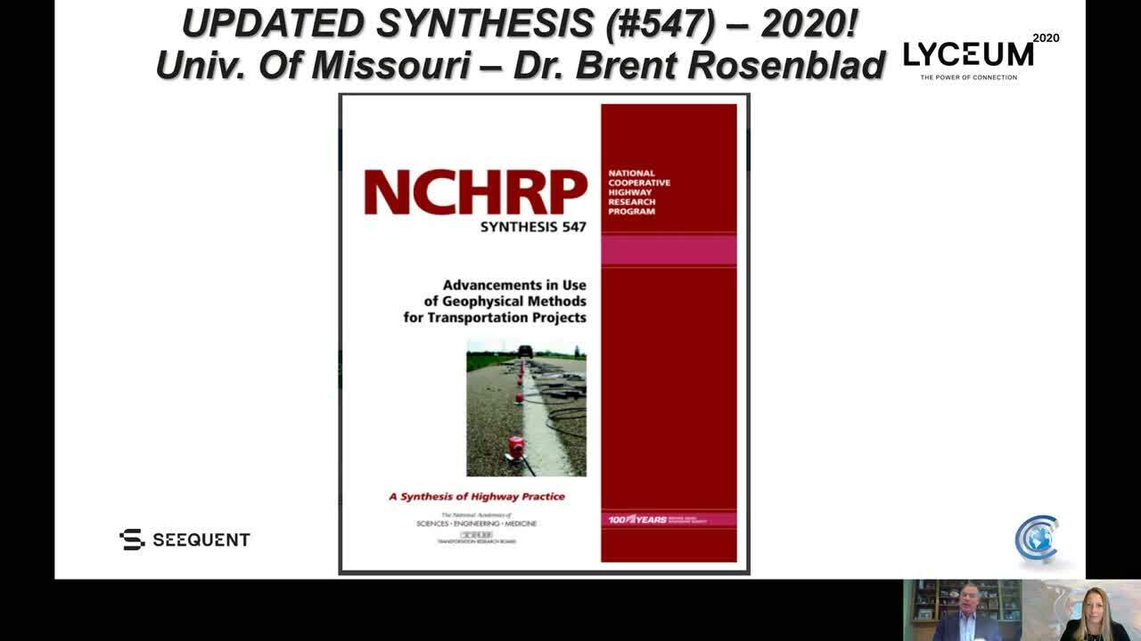
And then the last slide,
[00:05:33.794]
the one that one I had out of order,
[00:05:35.280]
is just a couple of days old, that a friend of mine,
[00:05:38.040]
Brent Rosenblad down at the University of Missouri
[00:05:40.480]
has just done the sequel to the synthesis
[00:05:42.620]
I did of 357 in 2006.
[00:05:45.360]
So we’ve gone back out to the states
[00:05:47.290]
and found out how much things are advanced, and they have.
[00:05:50.320]
We’re hoping for more, but they definitely have.
[00:05:52.770]
And that’s going to be real value for us,
[00:05:54.700]
because the more we know about the subsurface,
[00:05:57.147]
and the more we help the engineers, the better we’ll get.
[00:05:59.880]
And that’s where I have kind of a long-winded answer
[00:06:01.790]
on how I got involved,
[00:06:03.020]
but it’s been great fun for 20 years.
[00:06:05.618]
<v ->Oh, wonderful.</v>
[00:06:06.451]
And it’s great to see all of your expertise
[00:06:09.520]
and knowledge being put to good use,
[00:06:11.270]
and the use of geophysics coming,
[00:06:13.998]
being more at the forefront in transportation projects now.
[00:06:18.560]
When you think about the challenges
[00:06:20.830]
facing transportation projects,
[00:06:22.510]
what would you say the biggest ones are and how does the use
[00:06:25.650]
of geophysics help avoid risk?
[00:06:28.356]
<v ->Well, it’s definitely the understanding</v>
[00:06:30.903]
of subsurface from, you know, geologic conditions
[00:06:33.730]
to geo hazards.
[00:06:34.880]
And we could spend a lot time on finding faults,
[00:06:36.850]
and groundwater conditions or soils with heaving,
[00:06:39.600]
or soil in clays, but really the challenge to me
[00:06:42.560]
that I’ve seen throughout the career
[00:06:44.420]
has been at the funding level.
[00:06:45.990]
So the answer could be very short between the tax issues
[00:06:48.900]
that are going on and let’s just leave what’s going on
[00:06:51.210]
with the pandemic out.
[00:06:52.560]
This is always going to be
[00:06:53.530]
where funds get split very quickly.
[00:06:55.700]
They get split at the project and program level,
[00:06:59.250]
and they get split
[00:07:00.083]
somewhere around 75 or 80% goes to construction.
[00:07:02.947]
So that’s 20% to the early stages of design,
[00:07:06.060]
and somewhere between 10% of that
[00:07:08.160]
goes into program management administration.
[00:07:11.470]
And you’re down to about 10% for the engineers
[00:07:13.850]
to do designing, and the geotech’s
[00:07:15.570]
to do site characterization.
[00:07:17.650]
So as that money narrows down,
[00:07:19.780]
we’re working with the folks
[00:07:22.060]
that are out there taking direct measurements.
[00:07:23.560]
The engineers are using their drill rigs
[00:07:25.330]
to get cones and split spoon samples,
[00:07:28.090]
and take those to the lab,
[00:07:29.560]
crush the rocks, get the soils and do all the testing,
[00:07:33.320]
they have to do, a very direct measurement.
[00:07:35.360]
And then during the course of that, we bring in geophysics,
[00:07:38.150]
which is indirect measurements.
[00:07:40.830]
And as we start bringing those together,
[00:07:43.059]
and this understanding that that value is there,
[00:07:46.080]
but it’s the integration direct and indirect,
[00:07:48.130]
and the cross correlation that’s showing between them.
[00:07:50.877]
Putting those together is where
[00:07:52.460]
I think things are really going to progress.
[00:07:55.180]
Many states are starting to do this a lot.
[00:07:57.280]
Caltrans, in particular, I’ve mentioned them before.
[00:07:59.890]
So the ability to use indirect and direct measurements
[00:08:03.170]
is going to help us reduce risk.
[00:08:05.080]
I think I’ll circle back to that part of the question,
[00:08:07.330]
because I really see two factors
[00:08:09.700]
that are going to help us on that.
[00:08:11.290]
The first one is using the right tools.
[00:08:13.300]
Unfortunately, I have seen states use resistivity,
[00:08:16.590]
for example, for Rif ability.
[00:08:18.380]
That’s a seismic tool,
[00:08:19.660]
it’s for something very well understood on rock hardness.
[00:08:22.750]
So as long as the right tools are being used,
[00:08:24.730]
we’re going to be okay.
[00:08:25.850]
And the second is to simplify our results.
[00:08:28.940]
So just to use a few of the last slides we’re in,
[00:08:31.340]
if you’d bring that one up,
[00:08:32.660]
I’m going to show a couple of examples from Oklahoma,
[00:08:35.310]
where I think simplifying the results
[00:08:37.120]
was the best that I did with the geophysics.
[00:08:40.370]
This comes from a wind farm project,
[00:08:42.223]
and we did just shy of 300, 3D surveys
[00:08:46.250]
for the foundations in a Karst environment.
[00:08:48.680]
Who cares about the fun that we had in Oasis,
[00:08:50.990]
and spinning and using all that and integrating in Worbel,
[00:08:53.640]
it was coming up with a solution that was a green site
[00:08:56.550]
that you could build on, a yellow site
[00:08:58.460]
that needed more information,
[00:08:59.560]
or red sites, so you don’t build it.
[00:09:01.420]
So this is just an example of a table, of course,
[00:09:03.570]
with the coordinates all blocked out,
[00:09:05.380]
that would show all the information put in one,
[00:09:07.950]
the drilling, the proximity and the geophysics
[00:09:10.790]
to say what the Karst hazard is.
[00:09:13.200]
And the next slide there will show you
[00:09:14.930]
that most of our sites were agreeing.
[00:09:17.320]
And so the engineers are happy there,
[00:09:19.360]
but at the same time, very simple.
[00:09:21.600]
I can’t show you the map of these bridges,
[00:09:23.600]
a green, red or yellow dot was simplifying
[00:09:26.190]
a lot of information.
[00:09:28.160]
The next slide is a transportation project for ODOT,
[00:09:31.390]
where eight miles of resistivity was done.
[00:09:33.490]
And this just one very short segment,
[00:09:35.260]
a lot of plates for eight miles.
[00:09:37.240]
And it’s got all the great fun geophysics
[00:09:39.040]
down in the low left,
[00:09:40.150]
where I live with mapping ohmmeters and resistivity.
[00:09:44.120]
And that’s good.
[00:09:45.240]
I know exactly what it means,
[00:09:46.790]
but I hand this to an engineer and they might not.
[00:09:48.750]
They might be able to say, “Okay, I need to drill here,
[00:09:50.680]
I might not.”
[00:09:51.513]
But simplifying this is what the next slide was,
[00:09:54.600]
the result of working with the engineers at ODOT,
[00:09:57.590]
and my contractor to say,
[00:09:59.032]
“We need to make this very understandable.
[00:10:01.977]
We’ve got eight miles of data.
[00:10:03.860]
How about green is good, purple is not good,
[00:10:07.810]
and red is bad.”
[00:10:09.820]
So we did that on these.
[00:10:11.470]
And if you show the last slide, you’ll see that, you know,
[00:10:14.920]
the way to make happy engineers is a lot of green
[00:10:17.840]
and a lot of information that for miles,
[00:10:19.970]
is what the site was.
[00:10:21.310]
But if we narrow it down very quickly
[00:10:22.920]
to where the hazards are,
[00:10:24.350]
that’s going to be the best way to help reduce risk.
[00:10:28.330]
<v ->Great, thanks Phil.</v>
[00:10:29.776]
So what we’ve been seeing happen,
[00:10:32.104]
we’re seeing different transformations happening across
[00:10:35.240]
other industries where important assets
[00:10:37.262]
such as dams and bridges
[00:10:39.340]
are connecting geoscience data together.
[00:10:42.610]
And they’re building a geotechnical digital twin,
[00:10:45.550]
which is an interpretive 3D model of the physical asset.
[00:10:48.870]
What role do you see data management
[00:10:51.100]
and digital twins playing in mitigating risk
[00:10:53.380]
in improving the reliability for transportation projects
[00:10:56.290]
in the future?
[00:10:58.210]
<v ->When I knew you were going to ask this question,</v>
[00:11:00.130]
because these are set for you and I to discuss,
[00:11:02.113]
you know, I like it because I’m seeing
[00:11:04.240]
these as 3D models being so congruent, you know,
[00:11:07.110]
in our industry.
[00:11:07.943]
And I love what I’m seeing of the British Geologic Survey
[00:11:10.410]
out of the transportation sector.
[00:11:11.610]
It’s amazing work and we’re catching on.
[00:11:13.400]
Many of the states are doing the same.
[00:11:15.230]
And what you’re sharing today is a big piece of that,
[00:11:17.990]
because the digital twin to me
[00:11:19.330]
is it could be defined as value.
[00:11:21.640]
It’s data in the bank.
[00:11:23.240]
The best way to think of that, is all that information
[00:11:25.480]
that how many projects have you,
[00:11:27.240]
or I’ve worked on over the years, that 15 years later,
[00:11:30.430]
they call back and say,
[00:11:31.263]
“Hey, we’re going to start constructing that.”
[00:11:32.950]
And we go back to pay for space.
[00:11:34.880]
Now we’re going to go back to digital space
[00:11:36.750]
on all the projects that are coming up.
[00:11:38.450]
And I think it’s therein lies investment value
[00:11:40.950]
for the engineers and everybody that’ll take these data,
[00:11:43.720]
’cause never are they just straight fashion projects.
[00:11:46.350]
We start here and we end up constructing it.
[00:11:48.580]
So sometimes the delays, and also, conditions change,
[00:11:52.980]
you know, whether it’s the design of the foundation,
[00:11:55.130]
or the construction activities.
[00:11:57.150]
So keeping the ability to use GeoStudio and see,
[00:12:00.100]
hey, the slope stability changed on this,
[00:12:02.370]
we need to reanalyze that data, it’s there,
[00:12:04.800]
it’s in that data bank.
[00:12:06.250]
I think that’s incredibly powerful.
[00:12:07.730]
And that’s short-term, or long-term view of that dataset.
[00:12:11.050]
I think there’s only two pieces
[00:12:13.300]
that I’d like to incorporate there, maybe three.
[00:12:16.800]
And that is, when I’ve given short courses,
[00:12:18.920]
I say the best industry advances are,
[00:12:21.760]
first, we’ve got, you know, education and you saw
[00:12:24.530]
how we’re working on that for almost 20 years now.
[00:12:26.640]
We keep educating the client and that’ll never stop.
[00:12:29.240]
The second is our data processing ability.
[00:12:31.380]
We’re doing that in the field now.
[00:12:32.230]
You know, we’re sitting there and helping engineers decide
[00:12:35.445]
on today’s data tomorrow,
[00:12:37.900]
whether we keep going and we have enough,
[00:12:39.420]
or do we need more?
[00:12:40.840]
And that’s really valuable.
[00:12:42.420]
But I always thought the visualization
[00:12:44.600]
was the next greatest industry in advancement,
[00:12:48.170]
and using your Geosoft and sharing it with clients,
[00:12:51.200]
and going, “Okay look, you can see it here.”
[00:12:53.720]
But what I’ve learned from you and learn from working closer
[00:12:56.510]
with clients who are asking for our data
[00:12:58.160]
so they can use it in LeapFrog,
[00:12:59.930]
or any of the other products, is now it’s data integration.
[00:13:03.520]
That to me, has become the biggest industry advancement
[00:13:06.630]
that I’ve seen, and putting that
[00:13:08.050]
and making the site conceptual model,
[00:13:09.960]
let’s admit, we’re never going to be perfect.
[00:13:11.610]
Mother nature’s going to be certain of that.
[00:13:13.580]
But the more we get in there and the more we understand
[00:13:16.640]
these models, the better things will be,
[00:13:18.300]
and hopefully that’ll help with the funding.
[00:13:22.177]
<v ->Yes, that would be wonderful if it helps</v>
[00:13:25.000]
with the funding.
[00:13:26.610]
Oh, now I’ve been talking to organizations
[00:13:28.560]
like the California Department of Transportation.
[00:13:30.840]
You mentioned them earlier, Caltrans,
[00:13:32.870]
and they’re telling me that the trends in the industry,
[00:13:35.780]
that they’re doing themselves,
[00:13:37.580]
they’re mounting all kinds of equipment on cars,
[00:13:40.270]
and then they’re driving over their assets,
[00:13:41.890]
the roads and the bridges.
[00:13:43.800]
And they’re collecting geophysics,
[00:13:45.320]
they’re collecting Lidar,
[00:13:47.160]
infrared cameras and regular cameras.
[00:13:49.231]
And the amount of digital data collected today
[00:13:52.490]
is just increasing.
[00:13:54.920]
And now we’re seeing drones being used
[00:13:56.556]
and more instruments and sensors.
[00:13:58.969]
With this data explosion
[00:14:00.736]
comes an even better understanding
[00:14:02.910]
of both the subsurface and physical asset.
[00:14:06.570]
And how do you see software needs evolving
[00:14:08.560]
to keep up with this data explosion
[00:14:10.090]
in the transportation industry?
[00:14:12.412]
<v ->You know, that’s pretty good wording, data explosion,</v>
[00:14:14.590]
and geophysics are great at that.
[00:14:15.990]
We can generate the amounts of data that are just crazy.
[00:14:18.813]
And a good example of that,
[00:14:20.979]
I mentioned the SHRP2 program and working with Caltrans
[00:14:23.910]
on just one of their project in four hours,
[00:14:26.410]
which is one of those instruments you mentioned
[00:14:27.547]
that mounted on their van.
[00:14:29.950]
They collected over 4 terabytes worth of data of GPR
[00:14:33.130]
from a 3D instrument through tremendous amounts
[00:14:35.930]
of volume of data.
[00:14:36.763]
Well, storing it is important,
[00:14:38.439]
getting access to it is important,
[00:14:40.560]
making it in standardized formats is important.
[00:14:42.950]
And then the results of those being integrated
[00:14:45.340]
into the results.
[00:14:46.315]
That is where the site conceptual model is going.
[00:14:49.061]
But that’s just one day to say
[00:14:50.920]
going into a big volume is helping with utility conflicts,
[00:14:53.950]
or helping with slope stability and some
[00:14:56.327]
of the other hazards that are out there.
[00:14:57.600]
So I think a classic example I can give you is the one that
[00:15:00.690]
I mentioned earlier.
[00:15:01.850]
So on that wind farm in Oklahoma,
[00:15:04.810]
I sat down with geologists that didn’t know seismic.
[00:15:07.410]
They knew geology and they knew cars.
[00:15:09.620]
We were able to help them through a free viewer in Oasis,
[00:15:12.800]
so they had the software to answer your question.
[00:15:15.270]
If they can have the software and access to my data
[00:15:17.644]
and we’re sharing it together virtually or otherwise,
[00:15:20.799]
boy, you talk about value because suddenly
[00:15:23.500]
they started understanding and they’re putting
[00:15:25.610]
their drill hole in it or taking their blow caps
[00:15:27.610]
where together we’re combining it, say green or red,
[00:15:30.650]
on a construction site.
[00:15:32.090]
So that’s going to help, I think, for the long run,
[00:15:34.170]
it simplifies things, and that software,
[00:15:37.140]
as it continues to advance in utilization for everybody,
[00:15:42.090]
not just the geophysicist that needs it to process my data,
[00:15:45.390]
but in its utilization, that’s going to be real key.
[00:15:48.190]
<v ->Yes, that’d be quite powerful.</v>
[00:15:50.055]
Well, Phil, as we wrap up, just one final question for you.
[00:15:53.771]
How do you see geophysics evolving
[00:15:55.699]
to support transportation projects in the future?
[00:15:59.221]
<v ->I’d love to say forecasting is easy.</v>
[00:16:01.951]
It has been fun in 35 years to come,
[00:16:04.830]
from what I am, an analog guy, into a digital world.
[00:16:08.870]
I think some of the fun is going to be watching
[00:16:10.820]
the next generation.
[00:16:12.105]
You know, the digital generation,
[00:16:13.190]
take these tools that you’re sharing today.
[00:16:15.500]
And many others that we’re utilizing, on a daily basis,
[00:16:18.640]
to make this an everyday available product
[00:16:23.280]
for engineers that are working on any critical structure,
[00:16:25.900]
let alone transportation.
[00:16:27.670]
And as far as we’re paying attention
[00:16:29.680]
to what we’re putting in, we’re standardizing those things.
[00:16:32.160]
We’re making that conceptual model realistic and reliable.
[00:16:36.230]
Then the ability to build resilient structures
[00:16:38.920]
of any kind dams, levies, bridges, roads.
[00:16:41.670]
Those resilient structures,
[00:16:42.830]
that’s a goal worldwide for transportation agencies
[00:16:46.060]
and otherwise to say,
[00:16:46.893]
“That’s what we’re doing,
[00:16:48.210]
because it’s not just about building it.”
[00:16:50.070]
Then it’s about maintaining it.
[00:16:51.480]
And then it’s asset management after you have it.
[00:16:53.940]
And all of those being in the 3D digital world
[00:16:56.820]
is going to make, I think, things better.
[00:16:59.150]
Geophysics is a little piece of that.
[00:17:00.870]
So we’ve got to get better at geophysics in our own software
[00:17:04.460]
and joined in version,
[00:17:06.040]
and making sense of our information
[00:17:08.370]
to put it into these 3D models.
[00:17:10.462]
Because honestly, I think that’s where we’re going to have
[00:17:14.160]
the best bang for the buck,
[00:17:15.530]
because if we don’t help the decision makers
[00:17:19.140]
understand our data?
[00:17:20.500]
Who may not be geoscientists at all.
[00:17:22.920]
And if they understand what we’re trying to show,
[00:17:25.940]
and what we’re trying to use for our designs,
[00:17:28.410]
then we can really see, maybe a foresight budgeting,
[00:17:31.650]
way back to my very first answer.
[00:17:33.910]
And we’re putting these tools in play clear
[00:17:36.910]
at the design level, and maybe we’re getting a little
[00:17:39.130]
of those construction budgets for ourselves.
[00:17:43.049]
<v ->And that would be fun.</v>
[00:17:43.970]
Fantastic.
[00:17:45.115]
(both laughing)
[00:17:46.010]
All right, I’m just going to pull up your contact details here
[00:17:49.090]
before we move into the Q & A section,
[00:17:51.610]
and I just want to say thank you very much
[00:17:53.530]
for being our expert on this panel today
[00:17:55.630]
and sharing your knowledge and expertise with us.
[00:17:58.350]
So now we’ll take some live questions from the audience
[00:18:01.070]
and Phil will answer them.
[00:18:02.680]
Thanks Phil.